Well, when I started this blog, this wasn’t the trip we had in mind. Our goal was to paddle all around Vancouver Island this summer but as fate would have it, our plans changed. Instead, we did some hiking on the wild Nootka Island trail while Bryan’s broken hand healed up a bit and then did a month of leisurely kayaking in Clayoquot and Barkley Sounds on the west coast of Vancouver Island. We checked out remote beaches, relaxed in hotsprings, fished for our dinner and cooked up delicious meals over a small campfire. We took our kayaks up river and down the long exposed coastline between Tofino and Ucluelet. We explored the labyrinthine of islands in the Broken Group and high tailed it back to Ucluelet before the full force of what apparently was one of the worst storms in a decade. I thought the climax of the trip was making the run from Ahous Bay on Vargas Island to Ucluelet, completely exposed, but paddling in the vanguard winds of the storm beat it with a bang. It has been a pretty incredible summer and an amazing end of our two year long honeymoon. A quick shout-out to our wonderful and understanding sponsors: Princeton Tec, Wildcoast Publishing and Tilley Vancouver : THANK YOU!
Hidden gem: Calm paddling in the super tranquil Sulphur Passage behind Obstruction Island. The water is so calm that it perfectly reflects the sky and mountains like a mirror. To top it off, none of the busy tour boats comes back here…in fact, not many kayakers either. We saw no body in our whole time in the passageAfter waiting 3 days for the gale force winds settle down so we could paddle the outside of Flores Islands, we decided to head on the inside instead. I was a little sad at first because the outside of Flores Island is known for grey whales but instead, we were blessed with paddling for two hours with a pod of transient orca whales also heading down the inside!The long exposed coastline between Tofino and Ucluelet. This is a calm day out here with gentle rolling ocean swell.Gorgeous paddling in the Broken GroupFeeling thankful and really appreciating these islands by Ucluelet that gave us a bit of protected water. This was the first time we could stop and relax a bit after two hours of hard paddling over about 14km of stormy open waters from the Broken Group
Our kayaks at Granite Falls beach near the end of Indian Arm
Kayaking up Indian Arm is probably one of Vancouver’s best kept secrets where locals flock to on a sunny evening or weekend. It is close to Vancouver (transitable!), has a kayak rental place right at the beginning in Deep Cove (accessible for those who own or don’t own kayaks!) and it is a wilderness paradise (roads end soon after Deep Cove). Indian Arm is a steep-sided glacial fjord close to the city of Vancouver extending north for about 20km from Burrard Inlet. It was an easy choice for us for a practice paddle up Indian Arm last weekend with a couple friends in preparation for our larger journey around Vancouver Island this summer.
Map of Indian Arm
Indian Arm is at the heart of indigenous Tsleil-Waututh Nation since time immemorial. Since 1995, much of Indian Arm has been made into a provincial park named the Say Nuth Khaw Yum Heritage Park (aka Indian Arm Provincial Park), which is co-managed with Tsleil-Waututh Nation. Fun fact, a rough wilderness hiking trail goes around the perimeter of Indian Arm, created over many years by Don McPherson who also created the Grouse Grind!
Launching at Deep Cove
We started at Deep Cove near the entrance of Indian Arm. Burrard Inlet and the opening of Indian Arm was mapped first by Captain George Washington and then Indian Arm was fully explored later by Dionisio Alcala Galiano in 1792. Kayaking out of Deep Cove, we followed the western shore past gorgeous homes and old family cabins nestled into the cliffside.
Getting some help putting on my sprayskirt! I don’t remember it being THIS tight!! haha
Talking to another fellow who comes up here regularly, he said that there are two types of people who live up around Deep Cove and Indian Arm – the hippy, live off the land type and the independently wealthy. Well, after about 3km of paddling, we get up to Lone Rock Point where there is a small “lighthouse” beacon by a gorgeous home with its own helicopter perched precariously on wooden landing pad that pulled up from the beach. http://www.youtube.com/watch?v=Pm6vV6rPwgE Lone Rock Point is the closest crossing point to Raccoon Island. On hot summer days, a wind picks up in the afternoon whipping up the channel causing a bit of chop to the waves and lots of little powerboats, sailboats and yachts zipping around. However, the crossing is not long and soon we were at Raccoon Island. Raccoon Island is day-use only and apparently should be named Goose Island because it is invaded by Canadian Geese. As we paddled by Raccoon Island, a couple Canadian Geese trumpeted their dislike of our arrival.
Camping at Twin Islands
Twin Islands are about another kilometer further. The two islands are very close to the mainland and seem to detach themselves as we paddled closer and depth perception increased. The smaller southern island is day use only while the larger north island has five wooden tent pads nestled in the forest.
Trails on Twin Islands
There are little trails all over the small island that we wandered around in the afternoon all the way out to the northern tip of the island where there is a small “lighthouse” beacon and then trails south over the rocky hill and down to the small beach between the islands and a quick trail there back to the dock on the northeastern side of the island. The north island is covered by tall evergreen trees and a thick underbrush that is almost completely edible! Hardy green salal carpets the forest floor with delicate little white bell flowers hanging in a row. Huckleberry bushes already have plump red berries on them and a salmonberry bush welcomed us onto the island right off the dock ramp. Around dusk, a deer timidly wandered by very close to camp.
Salal
First huckleberry eaten of the season
The forest is edible! The forest floor is covered with salal and huckleberries
It was about 5.5km paddling from Deep Cove to Twin Islands. About 5km further north following the eastern shore, we came up to two old BC Hydro powerhouses built in the turn of the century where Gothic stone architecture made them look like an old castle. We paddle by Buntzen No 2. first, built in 1914 and then around the corner is Buntzen No. 1 built in 1903 to power Vancouver and upgraded in 1951. Penstocks direct water down from Buntzen Lake about 150 metres up the hill. The lake is in turn replenished though a tunnel from Coquitlam Lake, which was completed in 1905.
Approaching Buntzen No. 2 powerhouse
Though Buntzen No. 2 looks a little like a setting from a horror movie with broken windows and only the only sign of life is one fan high on the stone wall spinning away, they are still functioning. One unit at Buntzen No. 2 was shut down in 1972 but the two remaining units can still produce 17,800 kW. Both plants are remotely monitored and operated at a facility on Burnaby Mountain. On Buntzen No. 2 is a small sign that cautions people from getting to close as there can be sudden outflows of water. Ironically, the writing is so small that you need to be close to read it! Fun fact, Buntzen Lake and powerhouses is named after Johannes Buntzen, a Dane who was the first general manager of the BC Electric Railway and was called “the grandfather of electricity” in British Colombia!
Granite Falls 1887
After the long Buntzen Bay where Buntzen No. 1 is located, Croker Island comes into view in the middle of the channel and Granite Falls is tucked in behind. Granite Falls today is a beautiful wilderness boat-access-only campsite with about seven gravel tent pads and extra camping on a grassy field south of the falls. Though many people love Granite Falls for its wilderness, it was actually the site of a huge rock quarry as early as 1891. Stone from Granite Falls was used to construct grand new buildings in the young city of Vancouver around the turn of the century.
Granite Falls Quarry circa 1925
The Granite Falls Quarry bunk-house and cook-house were completely destroyed by fire in September 1946. Throughout the 20th century, the Indian Arm fjord was a popular destination for day-cruises, including a daily steamship up to the posh Wigwam Inn, originally opened as a luxury German resort and fishing lodge in 1910 located at the north end of Indian Arm (currently owned by the Royal Vancouver Yacht Club as an outstation for club members). In 1965, Granite Falls was the site of an ambitious resort project with a marina, lodge, dinner and dancing facilities, beer garden, roller skating pad, picnic area and horseshoe pitches.
Brochure of the Granite Falls Resort from 1965Picture of Granite Falls Resort 1965. The Galley is probably sitting right where we camped this past weekend!All that’s left today of the busy industry here in the past!
A view of the falls now….much different from the previous pictures from the past: http://www.youtube.com/watch?v=QSgRDCvo02c Today, it is a tranquil place with its campsites filled with paddlers. Boats come in for the day to splash around in the waterfall but then leave to anchor with other boaters in different areas.
The “Waterslide” at the base of the waterfall. The middle portion is the place to slide down rather than from where the water comes out. There is a bit of a drop from the first tier to the other which tilts people forward so they land headfirst into the shallow water. This is also the perfect water level…any more or less is dangerous. There is apparently a rock that sticks out if there’s less water that cuts people (a regular to the falls told us to look for the iconic 4 inch scar on the left shoulderblade on other visitors to the falls).
There is a lovely shallow pool at the base of the waterfall including a cool waterslide down the lower part when the water level is right (see picture for more info). However, the secret is to climb up to the second tier where the views are gorgeous and there is an emerald green pool deep enough to dive into. There is a beautiful cascade tumbling into the pool and more cascading down onto the ground. Follow the dried creek-bed on the south side of the waterfalls and then ironically, follow the dangers of climbing up the waterfall signs. It is a steep climb using roots as handholds and only go up to the second tier if the conditions are good.
Cascade into the lovely swimming hole up at the second tier of the fallsBryan taking in the gorgeous view from the second tier of the waterfall
However, the swimming fun is not just limited to the day. We went for a midnight dip in the bay where every movement sparkled with bioluminence. These glowing sparks are plankton that produces their own light through a chemical reaction when disturbed. It was very surreal to swim in the dark waters where each of our movements was followed by a swirl of light.
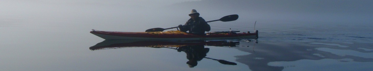
Perfect conditions in the morning leaving Granite Falls
There is a mass exodus from Granite Falls early Sunday morning. We all wanted to paddle out early when the fjord was calm. The water surface was like a mirror and fog curled out of the mountain sides. As the day heats up, the wind picks up and is channeled down the fjord into a challenging headwind. We crossed over to the western side of Indian Arm and stopped at Silver Falls about a third of the way back to Deep Cove. You can hear Silver Creek before you see it. The roaring sound leads us to a little nook with beautiful translucent green water and a waterfall behind some rocks. There is a lovely pool for some refreshing swimming.
Me at Silver Falls
Silver Falls
Our kayaks, Honeybee and Wavedancer, in the little cove by Silver Falls
Leaving Granite Falls at around 8am, we were back in Deep Cove by around noon after a leisurely 17km paddle. It has been a great paddle to get ourselves back onto the water and hang out with friends, Mike and Lauren!
Great times with great friends!! Thanks for all the fun, Mike and Lauren!!
How to paddle up Indian Arm:
You can launch your own kayak at the beach in front of Deep Cove Canoe and Kayak Center. If you have a vehicle, you can rent a kayak at MEC (cheapest) and bring it there. If you want really easy and/or don’t have a vehicle, you can rent at Deep Cove Canoe and Kayak Center and launch right there!
Paddling to Twin Island – best route is to kayak up the west side of Indian Arm up to Lone Rock Point for the shortest crossing to Raccoon Island and then Twin Island is only a little farther away. About 5.5km
Paddling from Twin Island to Granite Falls – stick to the east side of Indian Arm. You’ll see Buntzen No. 2 power plant from Twin Islands, which is about 5km away. Buntzen No. 1 is around the point in Buntzen Bay. After crossing Buntzen Bay, you’ll see Croker Island and Granite Falls is behind the island. About 12.2km
Paddling from Granite Falls to Deep Cove – cross to the west side of Indian Arm via Croker Island. Silver Falls is after about 6km and just before the first dock on the trip south. About 17km